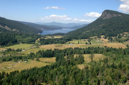
Aerial photo of the Fulford Valley and Mt Maxw ... 

Media-ID: B:715255498
Nutzungsrecht:
Kommerzielle und redaktionelle Nutzung
Aerial photo of the Fulford Valley and Mt Maxwell looking towards Burgoyne Bay and Maple Bay on Vancouver Island, Salt Spring Island, British Columbia, Canada
| Vorschau |
Varianten
Mediainfos
|
Dieses Bild mit unserem Kundenkonto ab $1.25 herunterladen!
|
||||
| Standardlizenz: JPG | ||||
| Format | Bildgröße | Downloads | ||
|
Print XXL 15 MP |
4288x2848 Pixel 36.31x24.11 cm (300 dpi) |
1 | ||
| Standardlizenz: JPG | ||||
| Format | Bildgröße | Netto | Brutto | Preis |
|
Web S 0.5 MP |
500x332 Pixel 16.93x11.24 cm (75 dpi) |
$5.15 | $5.50 | |
|
Print M 2 MP |
1000x664 Pixel 8.47x5.62 cm (300 dpi) |
$9.11 | $9.74 | |
|
Print XL 8 MP |
2000x1328 Pixel 16.93x11.24 cm (300 dpi) |
$17.03 | $18.22 | |
|
Print XXL 15 MP |
4288x2848 Pixel 36.31x24.11 cm (300 dpi) |
$20.99 | $22.45 | |
| Merchandisinglizenz: JPG | ||||
| Format | Bildgröße | Netto | Brutto | Preis |
|
Print XXL 15 MP |
4288x2848 Pixel 36.31x24.11 cm (300 dpi) |
$105.47 | $112.85 | |
| Media-ID: | B:715255498 |
| Aufrufe: | 1 |
| Beschreibung: | Aerial photo of the Fulford Valley and Mt Maxwell looking towards Burgoyne Bay and Maple Bay on Vancouver Island, Salt Spring Island, British Columbia, Canada |
Nutzungslizenz
| Nutzungsrecht: | Kommerzielle und redaktionelle Nutzung |
Userinfos
| Hinzugefügt von: | okephoto |
| Weitere Medien von okephoto |
Bewertung
| Bewertung: |
|
Suchbegriffe
| Keywords: |


