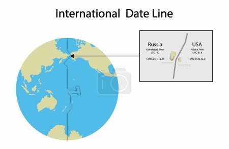
illustration of geography, International Date ... 

Media-ID: B:666066708
Nutzungsrecht:
Kommerzielle und redaktionelle Nutzung
illustration of geography, International Date Line map, line of demarcation, defines the boundary between calendar dates, Crossing the date line eastbound decreases the date by one day
| Vorschau |
Varianten
Mediainfos
|
Dieses Bild mit unserem Kundenkonto ab $1.25 herunterladen!
|
||||
| Standardlizenz: EPS | ||||
| Format | Bildgröße | Downloads | ||
| Vektorgrafik | eps | 1 | ||
| Standardlizenz: JPG | ||||
| Format | Bildgröße | Netto | Brutto | Preis |
|
Web S 0.5 MP |
500x327 Pixel 16.93x11.07 cm (75 dpi) |
$5.15 | $5.50 | |
|
Print M 2 MP |
1000x654 Pixel 8.47x5.54 cm (300 dpi) |
$9.11 | $9.74 | |
|
Print XL 8 MP |
2000x1308 Pixel 16.93x11.07 cm (300 dpi) |
$17.03 | $18.22 | |
|
Print XXL 15 MP |
6504x4253 Pixel 55.07x36.01 cm (300 dpi) |
$20.99 | $22.45 | |
| Standardlizenz: EPS | ||||
| Format | Bildgröße | Netto | Brutto | Preis |
| Vektorgrafik | eps | $13.07 | $13.98 | |
| Merchandisinglizenz: EPS | ||||
| Format | Bildgröße | Netto | Brutto | Preis |
| Vektorgrafik | eps | $105.47 | $112.85 | |
| Media-ID: | B:666066708 |
| Aufrufe: | 1 |
| Beschreibung: | Illustration of geography, International Date Line map, line of demarcation, defines the boundary between calendar dates, Crossing the date line eastbound decreases the date by one day |
Nutzungslizenz
| Nutzungsrecht: | Kommerzielle und redaktionelle Nutzung |
Userinfos
| Hinzugefügt von: | [email protected] |
| Weitere Medien von [email protected] |
Bewertung
| Bewertung: |
|
Suchbegriffe
| Keywords: |


