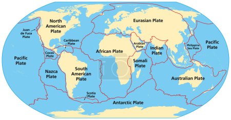
Map of the principal tectonic plates of the Ea ... 

Media-ID: B:675297376
Nutzungsrecht:
Kommerzielle und redaktionelle Nutzung
Map of the principal tectonic plates of the Earth. The sixteen major pieces of crust and uppermost mantle of the Earth, called the lithosphere, and consisting of oceanic and continental crust. Vector
| Vorschau |
Varianten
Mediainfos
|
Dieses Bild mit unserem Kundenkonto ab $1.25 herunterladen!
|
||||
| Standardlizenz: EPS | ||||
| Format | Bildgröße | Downloads | ||
| Vektorgrafik | eps | 1 | ||
| Standardlizenz: JPG | ||||
| Format | Bildgröße | Netto | Brutto | Preis |
|
Web S 0.5 MP |
500x260 Pixel 16.93x8.81 cm (75 dpi) |
$5.15 | $5.50 | |
|
Print M 2 MP |
1000x520 Pixel 8.47x4.4 cm (300 dpi) |
$9.11 | $9.74 | |
|
Print XL 8 MP |
2000x1040 Pixel 16.93x8.81 cm (300 dpi) |
$17.03 | $18.22 | |
|
Print XXL 15 MP |
9000x4681 Pixel 76.2x39.63 cm (300 dpi) |
$20.99 | $22.45 | |
| Standardlizenz: EPS | ||||
| Format | Bildgröße | Netto | Brutto | Preis |
| Vektorgrafik | eps | $13.07 | $13.98 | |
| Merchandisinglizenz: EPS | ||||
| Format | Bildgröße | Netto | Brutto | Preis |
| Vektorgrafik | eps | $105.47 | $112.85 | |
| Media-ID: | B:675297376 |
| Aufrufe: | 1 |
| Beschreibung: | Map of the principal tectonic plates of the Earth. The sixteen major pieces of crust and uppermost mantle of the Earth, called the lithosphere, and consisting of oceanic and continental crust. Vector |
Nutzungslizenz
| Nutzungsrecht: | Kommerzielle und redaktionelle Nutzung |
Userinfos
| Hinzugefügt von: | Furian |
| Weitere Medien von Furian |
Bewertung
| Bewertung: |
|
Suchbegriffe
| Keywords: |


