Rocky Mountain region of the United States, po ... 

Media-ID: B:706070606
Nutzungsrecht:
Kommerzielle und redaktionelle Nutzung
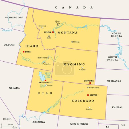
Rocky Mountain region of the United States, political map. The Rocky Mountains, Rockies for short, divide the western United States from the Great Plains. Colorado, Idaho, Montana, Wyoming, and Utah.
| Vorschau |
Varianten
Mediainfos
|
Dieses Bild mit unserem Kundenkonto ab $1.25 herunterladen!
|
||||
| Standardlizenz: EPS | ||||
| Format | Bildgröße | Downloads | ||
| Vektorgrafik | eps | 1 | ||
| Standardlizenz: JPG | ||||
| Format | Bildgröße | Netto | Brutto | Preis |
|
Web S 0.5 MP |
500x500 Pixel 16.93x16.93 cm (75 dpi) |
$5.15 | $5.50 | |
|
Print M 2 MP |
1000x1000 Pixel 8.47x8.47 cm (300 dpi) |
$9.11 | $9.74 | |
|
Print XL 8 MP |
2000x2000 Pixel 16.93x16.93 cm (300 dpi) |
$17.03 | $18.22 | |
|
Print XXL 15 MP |
6000x6000 Pixel 50.8x50.8 cm (300 dpi) |
$20.99 | $22.45 | |
| Standardlizenz: EPS | ||||
| Format | Bildgröße | Netto | Brutto | Preis |
| Vektorgrafik | eps | $13.07 | $13.98 | |
| Merchandisinglizenz: EPS | ||||
| Format | Bildgröße | Netto | Brutto | Preis |
| Vektorgrafik | eps | $105.47 | $112.85 | |
| Media-ID: | B:706070606 |
| Aufrufe: | 1 |
| Beschreibung: | Rocky Mountain region of the United States, political map. The Rocky Mountains, Rockies for short, divide the western United States from the Great Plains. Colorado, Idaho, Montana, Wyoming, and Utah. |
Nutzungslizenz
| Nutzungsrecht: | Kommerzielle und redaktionelle Nutzung |
Userinfos
| Hinzugefügt von: | Furian |
| Weitere Medien von Furian |
Bewertung
| Bewertung: |
|
Suchbegriffe
| Keywords: |


