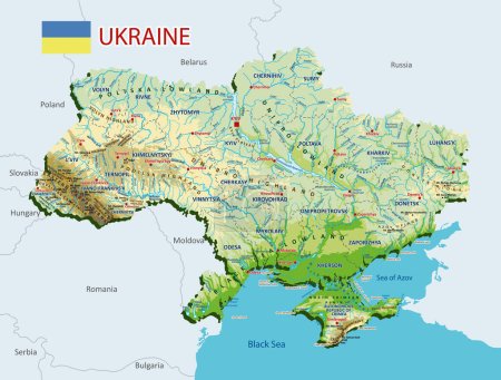
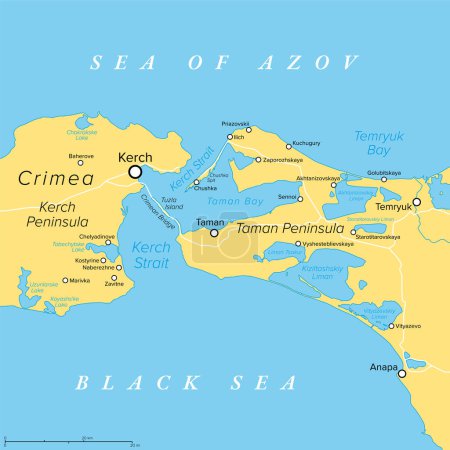
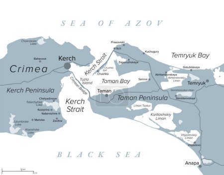
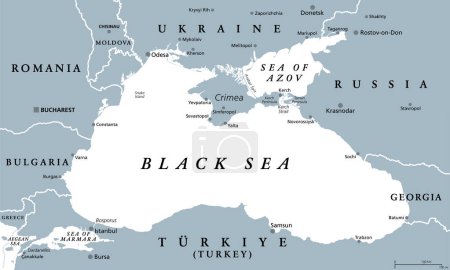
37 Vektoren zum Thema "sea of Azov" bei ClipDealer

Medien sortieren nach     Gehe zu Seite:    
« Vorherige  1  Nächste »
sunrise seascape and seagull
Marine mammals collection. Different porpoises set. Cartoon flat
sunrise seascape and seagull
Dried fish vector
Atherina notata, Dotted Silverside or Big-scale sand smelt fish.
Marine mammals collection. Different porpoises set. Cartoon flat
European garfish fish, isolated on light background. Fresh seafood in a simple flat style. Vector for design marine life and illustration market packaging. EPS10. Ocean, inhabitants water.
Crimea political map. Peninsula in Eastern Europe on the northern coast of the Black Sea, with disputed status. Controlled and governed by Russia, internationally recognized as part of Ukraine. Vector
Coat of arms of Taganrog is a port city in Rostov Oblast, Russia, on the north shore of the Taganrog Bay in the Sea of Azov. Vector illustration
Three dried fish
Autonomous Republic of Crimea - vector map
Map of Ukraine
Map of Ukraine for your design
Ukraine in the form of flag
black sea map, vector illustration
Map of Ukraine
Ukraine Political Map
Map of Ukraine
Topographic map of Ukraine. Geographic map of Ukraine with borders of the regions. High detailed Ukraine physical map with labeling. Atlas of Ukraine with rivers, lakes, seas, mountains and plains.Vector illustration
Explore ukraine flat poster set depicting traditions culture and landmarks isolated vector illustration
Kerch Strait in Eastern Europe, political map. It connects the Black Sea and Sea of Azov, separating the Kerch Peninsula of Crimea from Taman Peninsula. The Crimean Bridge connects both peninsulas.
Black Sea and Sea of Azov region political map
eps vector illustration with silhouette of country ukraine with country colors
Kerch Strait in Eastern Europe, gray political map. Narrow waterway that connects the Black Sea and Sea of Azov. The Crimean Bridge connects the Kerch Peninsula of Crimea with the Taman Peninsula.
Ukraine, administrative divisions, gray political map. Country and unitary state in Eastern Europe, with capital Kyiv (Kiev). Country subdivision, with administrative centers. Illustration over white.
map of the city of Mariupol, Ukraine
ukraine in hand
Ukraine political map
eps vector illustration with country ukraine and administrative divisions, oblasts, autonomous republics and special cities
Black Sea region, gray political map. Marginal mediterranean sea of the Atlantic Ocean, between Europe and Asia. With Crimea, Sea of Azov, Sea of Marmara, Bosporus, Dardanelles and the Kerch Strait.
Map of Ukraine
Ukraine flat icons set depicting history cuisine national traditions orthodox monuments of architecture isolated vector illustration
Map of Ukraine
Ukraine map flat poster with architectural monuments landmarks cuisine and tradition icons vector illustration

« Vorherige  1  Nächste »